ARPA-E SMARTFARM · SUCCESSFUL PROGRAM
AGRICULTURE · MID-INFRARED SPECTROSCOPY

Map what the field is emitting.

This is a spectroscopy application, not an Intelligent Material crystal application. Mid-infrared lasers and infrared detectors can measure trace gases above crops, locate emission hot spots and turn a field into a spatially resolved environmental data set.

HOW SMARTFARM MAPS A FIELD Laser paths across the field become a map of where N₂O is coming from. ① Mid-IR laser scansbeams sweep the field ② Reflectors return lightgas along each path absorbs ③ Map + drone checkhot spot confirmed from above N₂Olowhigh
SMARTFARM

A successful ARPA-E program became field hardware.

The SMARTFARM program brought Princeton University, IMS and specialist laser partners together to build a practical way to quantify agricultural nitrous oxide emissions. The concept combined long-path mid-infrared spectroscopy around the field with a lightweight UAV sensor for spatial validation.

4.542 µmInterband cascade laser wavelength used by the UAV N₂O sensor.
10 HzHigh-frequency gas measurements suitable for a moving UAV.
0.1 ppbvLaboratory precision demonstrated by the open-path sensor.
7 WLow sensor power draw supporting practical field deployment.
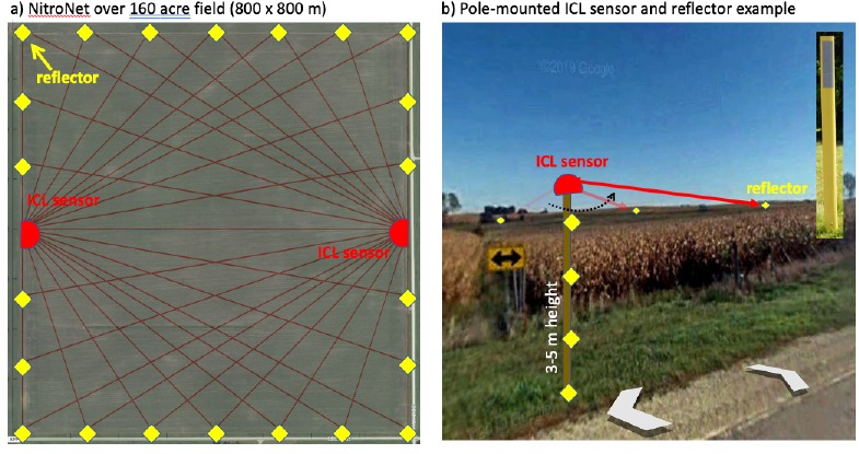
NitroNet SMARTFARM field spectroscopy concept
SMARTFARM concept: scanning mid-infrared paths and passive reflectors around an agricultural field.
THE FIELD AS THE SAMPLE

Cast a virtual optical net across the farm.

The original NitroNet architecture used scanning mid-infrared laser beams and low-cost retroreflectors around a field. Multiple path-integrated measurements can be reconstructed into spatial concentration maps rather than treating the entire farm as one average number.

That creates a route to finding both hot spots in space and hot moments in time — exactly the information needed when fertilizer, irrigation, soil and crop conditions vary across a field.

N₂OLong-path spectroscopyTomographic mappingRetroreflectorsPrecision agriculture
FIELD VALIDATION

From proposal to a flying sensor.

The later UAV system used an open-path ICL sensor and MCT detector to make geolocated N₂O measurements above agricultural fields. Laboratory measurements agreed closely with a commercial closed-path analyzer, and field flights mapped concentration structure across a soybean field.

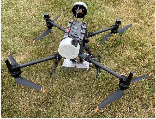
UAV carrying open-path nitrous oxide spectroscopy sensor
Open-path N₂O spectroscopy sensor mounted to a DJI Matrice 350 UAV.

Take the spectrometer to the plume.

The open-path architecture avoids a power-hungry sampling pump and keeps the system compact enough for UAV operation. GPS and high-rate measurements let each gas reading be tied to a location.

The same sensing approach can also move onto autonomous ground vehicles or portable platforms when the application calls for a different geometry.

UAVICLMCT detectorWMSGPSOpen path
WHAT THE DATA ENABLES

Measure the consequence of farm management.

Nitrous oxide is strongly tied to agricultural nitrogen use. Mapping its distribution creates a measurement layer that can be compared with fertilizer application, irrigation, soil conditions and management practices.

The point is not simply to detect N₂O. It is to provide spatial and temporal information that can support better decisions about where and when emissions are occurring.

A spectroscopy platform can turn greenhouse-gas measurement from an occasional laboratory-style exercise into repeatable field intelligence.
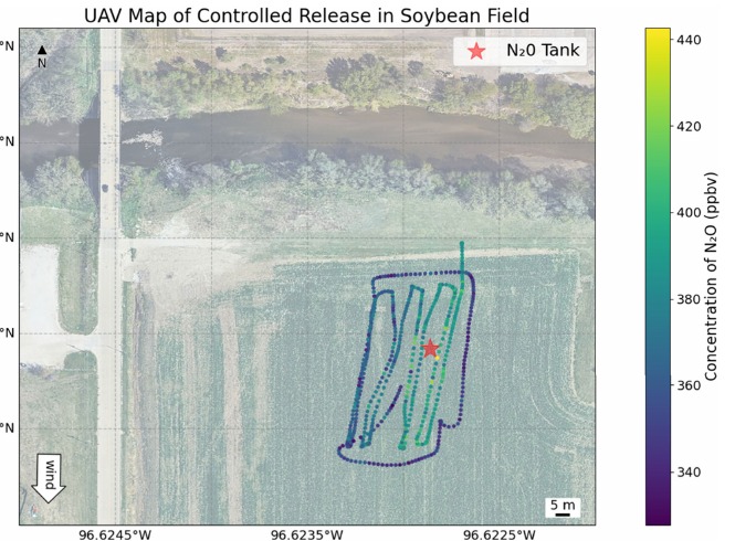
Geolocated N2O map from UAV field measurement
Example field map from the UAV program showing geolocated N₂O concentration measurements and a controlled source.
AGRICULTURE SPECTROSCOPY

One optical architecture. More than one gas.

The SMARTFARM work centered on nitrous oxide, but mid-infrared spectroscopy is fundamentally wavelength-selective. Changing the laser wavelength, optical path and calibration architecture opens additional agricultural and environmental targets.

01 · NITROUS OXIDE

Fertilizer efficiency + emissions

Map N₂O concentration structure and identify hot spots and hot moments associated with field conditions and nitrogen management.

02 · AMMONIA

Nutrient loss + livestock

QCL-based architectures can target NH₃ for fertilizer, feedlot and agricultural air-quality applications.

03 · METHANE + OTHER GASES

Expand by wavelength

The same broader mid-IR platform can be adapted to other molecular species where a useful absorption feature and deployable optical geometry exist.

SMARTFARM SPECTROSCOPY

Measure the field, not just a sample from it.

IMS develops application-specific mid-infrared sensing architectures with Princeton and photonics partners for agriculture, environmental monitoring and other trace-gas applications.

Discuss a SmartFarm spectroscopy program →